THE NATIONAL MALL: An Illustrated History
II. The 1791 L’Enfant Plan and the Mall
 |
 |
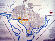
| FIGURE 2: The L'Enfant Plan of 1791 (left) and detail of the Mall area (right). Click on left map for higher resolution (236k). |
In 1791, at George Washington's request, Peter (Pierre)* L'Enfant drew up a plan for a city 10-miles square and centered on the Congress House (Capitol).
The L'Enfant Plan laid out the Nation's Capital as a physical embodiment of the newly ratified U.S. Constitution. The Capitol Building marked the city's center and highest spot. Broad diagonal avenues named for the 13 colonies overlaid a grid of residential streets. Pennsylvania, site of the Constitutional Convention, gave its name to the avenue connecting -- and separating -- the Capitol and White House. Circles and rectangles formed at the intersections of avenues and streets were to be sites for monuments, memorials, and public buildings.
Within this vision of great symbolic spaces, vistas, and public buildings, L'Enfant planned the Mall as a 400-foot wide Grand Avenue (shown in yellow in the plan), extending from the Capitol westward to the Washington Monument (marked "A" in the plan) at the banks of the Potomac River where it intersected the White House axis (marked "President’s House" in the plan). He described the Mall as a "place of general resort" and, echoing Thomas Jefferson, a "public walks", a tree-lined promenade flanked by public buildings such as theaters, academies, and assembly halls.
*We now know that L’Enfant called himself "Peter" and not Pierre. See Kenneth R. Bowling, Peter Charles L’Enfant: Vision, Honor, and Male Friendship in the Early American Republic, 2002.
Next: The 19th Century and the McMillan Plan of 1901-1902
|